This time last year the weather forecast for the Western Alps looked apalling. We managed to complete the mission - The Stelvio - before getting a right soaking.
Link to Stelvio trip
This year, the forecast is Disney:
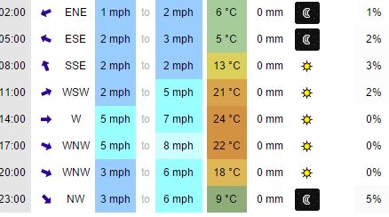
So far, five days of the above is on the cards.
I've put in the training - the Spring Dash plus lots of Strava uploads.
Link to Normandy Dash
Weight is down to 13st 10 and with a few more choice pieces of light kit and lower gears, I'm all set for the hairpins.
Later today, it's off to St. Pancras to drop off the steed.
Where to? Well, you'll just have to tune in...
For a change this year's trip took off with a train or two. I don't like flying or the stress of preparing the bike and my kit for an outward flight - especially at 5.30am. So, instead, of the jet setting, I tested the capabilities of rail travel to see how I'd get by with an assembled bike.
After wads of research involving the labyrinth-like bowels of the SNCF website - in French - I came upon a hidden world of possibilities. You have to avoid TGV and head, instead, onto the Intercitie, Corail and TER services to see what is available for assembled steeds. I discovered that there is an overnight train to the French Alps - one takes assembled bikes. Eurostar itself is straightforward and has options for the bike. Once you have ascertained what you want to do, call Rail Europe - SNCF's UK offshoot - and book over the phone as the bike option is not available online. They'll process both the Eurostar and SNCF tickets.
Having paid £36 for the fare, £25 for the bike for Eurostar, then £25 + £10 for the overnight train, the cost beat the air trip.
And so...
Took the 16.22 from St. Pancras and arrived at the Gare du Nord at 20.00. Once through the gateline, we picked up the bikes after a walk to the Geoparts baggage depot in the Gare du Nord, right back out at the end of the westernmost platform where the Eurostar services operate. If you are also leaping on the charabanc of l'aventure, take the side exit by Geoparts onto Rue de Alsace to head north a short way onto Lafayette where you'll find a bike lane heading east taking you over a bridge stretching over the lines in and out of Gare Du Nord. Follow this lane until you reach the Canal St. Martin then head south on the east bank. This cyclepath will take you all the way to the Seine, where another path delivers you to Gare d'Austerlitz in plenty if time for the 22.27 to Annecy.

The train has no bar/food so stock up at a Monoplus minimarche just down Boulevard de l'Hopital.
Boarding the train was all very relaxed with the bonus that the six berth cabin just had me and booked in; the bikes were right nextdoor. We travelled on a Wednesday evening so off-peak is worth considering.

 7.00am: Out of the train, chuck the panniers back on the bikes and into Annecy, asleep by lake. After a twist here and a turn there, we followed the Albertville signage so as to pick up the 32-mile cycle route to Albertville. This is a stand alone path for most of the way, along the very pretty Lac d'Annecy. If you want to overdo it with pastries and coffee first thing find a café in Annecy as there was nothing open at this hour until Le Brouillet.

Albertville held only one interest for us: the funtabulous Decathlon and its shiny outdoory sporty things that people come hundreds and hundreds of yards to see and touch. We indulged in a blanket, airbed, USB charger pack and the ever so necessary Primus Gas. What with the Euro hovering just above the floor, the gear was almost dirt cheap. Darned awkward to find the store though. After doubling back we found a quiet road that doubled as a cycle route that took us westwards and downhill beside the ice blue l'Isere on its way to la Rhone at Grenoble.
 We lunched on Intermarche taboula by a lagoon before turning left at Aiton to head upwards and southeastwards to La Chambre against the flow of l'Arc.
Today's ride is all about warming up for the following days and their cols. The road was busy - the D1091, another route across the Alps was shut closed due to a landslip.
 A cup of tea at La Chambre brought back fond memories of the last time we had a cup of tea at La Chambre. Once again it was gearing up for a visit by the TDF, already underway and in Brittany.
Beyond La Chambre the valley becomes industrial with several quarries chewing away at the receding granite batholiths. The road gets busier with dusty trucks but after a while we arrive at St. Michel de Maurienne. The very welcoming but strange campsite of Le Marintan is right at the end of the town. Its tent pitches are small levelled areas on terraces set in a steep hill side. Le Marintan is a base for cyclists having a go at the cols that line the valley - the most infamous being the Telegraphe-Galibier combo. But it is also well placed for La Madeleine, Glandon, Croix de Fer and a bunch more. Swanky chalets can be rented if you don't fancy bending your tent pegs in the cement-like earth. A small Carrefour in the town will help out with banana supplies for the hatful of rides.
For the most part, this 81-mile gentle ride is beautiful as you head from the green moistness of the Rhone Alpes towards the drier Provence-Alpes-Côte d'Azur.

After wads of research involving the labyrinth-like bowels of the SNCF website - in French - I came upon a hidden world of possibilities. You have to avoid TGV and head, instead, onto the Intercitie, Corail and TER services to see what is available for assembled steeds. I discovered that there is an overnight train to the French Alps - one takes assembled bikes. Eurostar itself is straightforward and has options for the bike. Once you have ascertained what you want to do, call Rail Europe - SNCF's UK offshoot - and book over the phone as the bike option is not available online. They'll process both the Eurostar and SNCF tickets.
Having paid £36 for the fare, £25 for the bike for Eurostar, then £25 + £10 for the overnight train, the cost beat the air trip.
And so...
Took the 16.22 from St. Pancras and arrived at the Gare du Nord at 20.00. Once through the gateline, we picked up the bikes after a walk to the Geoparts baggage depot in the Gare du Nord, right back out at the end of the westernmost platform where the Eurostar services operate. If you are also leaping on the charabanc of l'aventure, take the side exit by Geoparts onto Rue de Alsace to head north a short way onto Lafayette where you'll find a bike lane heading east taking you over a bridge stretching over the lines in and out of Gare Du Nord. Follow this lane until you reach the Canal St. Martin then head south on the east bank. This cyclepath will take you all the way to the Seine, where another path delivers you to Gare d'Austerlitz in plenty if time for the 22.27 to Annecy.

The train has no bar/food so stock up at a Monoplus minimarche just down Boulevard de l'Hopital.
Boarding the train was all very relaxed with the bonus that the six berth cabin just had me and booked in; the bikes were right nextdoor. We travelled on a Wednesday evening so off-peak is worth considering.


Albertville held only one interest for us: the funtabulous Decathlon and its shiny outdoory sporty things that people come hundreds and hundreds of yards to see and touch. We indulged in a blanket, airbed, USB charger pack and the ever so necessary Primus Gas. What with the Euro hovering just above the floor, the gear was almost dirt cheap. Darned awkward to find the store though. After doubling back we found a quiet road that doubled as a cycle route that took us westwards and downhill beside the ice blue l'Isere on its way to la Rhone at Grenoble.
 We lunched on Intermarche taboula by a lagoon before turning left at Aiton to head upwards and southeastwards to La Chambre against the flow of l'Arc.
Today's ride is all about warming up for the following days and their cols. The road was busy - the D1091, another route across the Alps was shut closed due to a landslip.
 A cup of tea at La Chambre brought back fond memories of the last time we had a cup of tea at La Chambre. Once again it was gearing up for a visit by the TDF, already underway and in Brittany.
Beyond La Chambre the valley becomes industrial with several quarries chewing away at the receding granite batholiths. The road gets busier with dusty trucks but after a while we arrive at St. Michel de Maurienne. The very welcoming but strange campsite of Le Marintan is right at the end of the town. Its tent pitches are small levelled areas on terraces set in a steep hill side. Le Marintan is a base for cyclists having a go at the cols that line the valley - the most infamous being the Telegraphe-Galibier combo. But it is also well placed for La Madeleine, Glandon, Croix de Fer and a bunch more. Swanky chalets can be rented if you don't fancy bending your tent pegs in the cement-like earth. A small Carrefour in the town will help out with banana supplies for the hatful of rides.
For the most part, this 81-mile gentle ride is beautiful as you head from the green moistness of the Rhone Alpes towards the drier Provence-Alpes-Côte d'Azur.

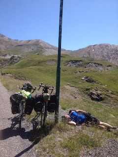
The plan was to get up early, fresh as daisies, to tackle the monsters ahead before the sun really got going. And so we left Saint Michel at 10am, just the two hours late, just as the sun got going.
There is no faffing about with the Télégraphe. The climb starts in St. Michel itself and you're into 7-8% from the off. The installation on the col overlooks the town from a sheer drop.
The road twists and turns all over the place but does so in the shade of the trees that occasionally reveal the increasingly stunning view of the l'Arc valley below. At 1566m it is not a tough climb on its own - we managed its 11km in two hours.
The Col du Télégraphe lacks a sense of achievement as not only is it severely dwarfed by the main course, the Galibier, but there is also a downhill to Valloire, undoing a couple hundred of metres of elevation wrested from your thighs in getting up the Télégraphe.

The easy descent into Valloire takes 10 minutes. The town is a ski resort of varnished pine and frilly flowery garnishes. Shops bulge with walking sticks and half-price skiwear. After the regulation coffee and stack of pastries we availed ourselves of the Carrefour just by the D902's signpost to the Galibier for essential rations. We met a Dutchman in his mid-sixties heading that way too. Square jawed, weathered leathery skin and a distant, faraway look in his glistening eyes, he was the perfect specimen of a lone tourer. However, his bike was configured for CC riding, thus falling short of the criteria required for extreme touring - no tent, slipping bag and mat!
CC Rider on youtube
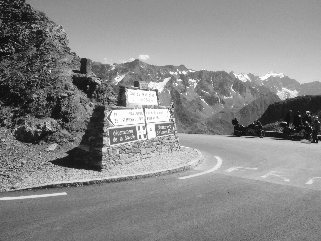
 The Col du Galibier starts off easy enough but without the forest of the Télégraphe, the heat counters the easier gradient. The col saps your strength and resolve in the second half of the 18km as the valley is straight up and exposed, the road following the river Valloirette beneath steep cliffs and scree. Flies gather and investigate your eyes, earhole and nostrils. You get passed by an e-bike; motorcades of bikers on immaculate Harleys and Beamers glide by. Eventually, the Dutchman flew past us and D, like a dog after a ball, left me behind for the chase.
Things take a turn for the worse just after the very welcome café Rosa, where The Dutchman had left D for dead. The road leaves the valley and hurdles a moraine of some sort in a series of steep 'ramps' before settling down again.

As with most cols the steepest bit is the final couple of km, though the Galibier, from this side, does manage to stay within 10% for most part.

Not much at the top except the photo shoots in front of the sign - and spectacular views from what is one of the Alps' highest roads. We'd almost chased down the Dutchman but nearing the top he'd given us the slip and he was revelling in congratulations from motorists and bikers alike. D and I got a few claps too as we stretched the sinews for the triumphant spurt for the line.


Grabbed some bananas and biscuits from the site's store and cycled back towards Briançon to rejoin the D902. Hang on a minute, you might say, the D902...again?
The D902 is the Route 66 of the Alps. Much of it is the Routes des Grande Alpes, and takes the traveller over some of the highest roads and passes in the French Alps. Starting in Thonon les Bains on Lake Geneva, it becomes a little confusing to follow as the road number frequently vanishes throughout its journey. After taking in the Col d'Iserean it disappears only to resurface at Saint-Michel de Maurienne for the hop over the Télégraphe and Galibier before being absorbed into the D1091, which follows the Durance. It then reappears miraculously outside a garden centre in Briançon for the Izoard. It then returns, somewhat needlessly back to the Durance valley at Guillestre then up the Vars where it vanishes once more before resurfacing down in the Ubaye valley for a journey south where it becomes yet another road.
French Departments have their own numbering system and so as you cross into an adjacent Department, the number changes. Proper dinner party stuff.

The first third of the Izoard is easy going and passes through several villages and there is a great view back over the Durance Valley and the Ancien Fort des Trois Têtes perched high on a cliff overlooking Briançon.
The flies came pretty thick and fast through the warm valley and I came up with the bright idea of shoving a banana skin in the cup hanging off my back rack to distract them.
I'd upgraded my cogs over the winter and in spite of the 15kg of assorted gear and gubbins, the 22front/32back was more than adequate for the gradients. I managed granny+1 for most of the 7-9%.It was the heat and residual booze that caused me to groan in despair.

Mind over matter gets you up cols and you have to employ that steely resolve when all manner of cyclists fly past you on their seemingly casual morning spin. They don't grunt or sweat; they even say 'Bonjour' with a happy smile and a wave. All you have to do is beat them to it with an even lighter and airier 'Bonjour'. At a café somewhere a man on a feather-lite carbon wisp of a bike asked how much my bike and gear weighed - 28/29 kg. His was 7kg. He was gobsmacked.

Overall, the Izoard is not as tough as the Galibier and, it too, has a down hill bit or two. It does have its moments though - particularly the last five km. There is a long stretch between 11% ramps and if you inadvertently lift your eyes from the blur of your tyre tread and look ahead, way up high in the distance you can see cars on the final bend, shimmering in the sun. This can be a bit deflating as the mystery of how the climb finishes evaporates - you now know it is up some serious ramps and miles away!

The Izoard is however more spectacular than the Galibier, and the column marking the col is impressive even if it is a bit difficult to get in to a photo.


Just down from the top and around the bend - literally - is an eerie moonscape that provides a reminder that the Alps are not exactly set in stone - the scenery is changing all the time.


What the Izoard also has, for a slightly cautious downhiller like me, are some fantastic stretches lower down the descent where you can open up and use the big gears.
I managed to clock 42.7mph.

Instead of heading back down to Guillestre on the D902, as many cyclists were doing, we hung a left onto the D947 to head up the Guil Valley to Ville Vieille and the Iscle campsite.

Before you get to this site there is a small village beneath the imposing Fort Queyras with an expensive shop/bar but just beyond the end of campsite is a Carrefour, so you can hang on for supplies if you don't fancy shelling out.
This is a nice campsite though the ablutions block is shared with local flies. There is a TV room with a few plugs and a few patches of soft-ish earth.


 I had never heard of the Col d'Agnel (Colle d'Agnello) before pondering this year's trip. It is one of border colles between France and Italy and the highest at 2760m. If tackled from Guillestre it is a whopping 42 km and from where we were camped it was still 25km. This distance puts it up there with la Bonnette, yet it is not well known among cyclists even though it has featured twice in the TDF in 2008 and 2011. It is truly a monster, possessing both length and nasty gradients - and that's just from the western side; try it from Italy and it is a wall. Other than all that it is a magnificent ride.


There are several villages along the route - more or less a straight ride up the valley, which makes it quite an unusual ride, though there is the usual intestinal stuff in the the final kms. Most cyclists we'd met on the Izoard were heading for Vars so the day was quiet but for the motorcades of Italian bikers.


 Agnel is 84th on climbbybike's league of France's hardest climbs - perhaps because it has been ridden by fewer riders. There is a good reason for that. Unless you're going to turn around and come straight back down, you will have committed yourself to a very long downhill out of the Alps and out on to the plains of Piemonte - which is exactly what we did.
The east side is steep and the road narrow so the brakes did a lot of squealing on the descent. Plenty of cheeky drivers trying to steel and inch didn't help. One feature were the very neat table-and-chairs Sunday picnics set up on bends; the Piemontese had escaped the heat of the plains below for the relative cool of the mountains.
Down in Casteldefino we stopped off for very good and cheap pizza before busting a gut to get to Cuneo.
With the broadening of the valley the scenery got drearier and distant. We were treated to eight miles of dead straight road that took us into the impressive town.
We took a train up to Limone Piemonte for the neat and tidy Luis Matlas campsite. Limone is a bustling upmarket ski-resort that provides another retreat from the heat.
More pizza.

Another great downhill. The good road and long, not-so-steep stretches allowed me to hit 42.7mph. Instead of continuing to Guillestre on D902 we headed up the valley on D947 for the Col d'Agnel
There is no faffing about with the Télégraphe. The climb starts in St. Michel itself and you're into 7-8% from the off. The installation on the col overlooks the town from a sheer drop.
The road twists and turns all over the place but does so in the shade of the trees that occasionally reveal the increasingly stunning view of the l'Arc valley below. At 1566m it is not a tough climb on its own - we managed its 11km in two hours.
The Col du Télégraphe lacks a sense of achievement as not only is it severely dwarfed by the main course, the Galibier, but there is also a downhill to Valloire, undoing a couple hundred of metres of elevation wrested from your thighs in getting up the Télégraphe.

CC Rider on youtube
 The Col du Galibier starts off easy enough but without the forest of the Télégraphe, the heat counters the easier gradient. The col saps your strength and resolve in the second half of the 18km as the valley is straight up and exposed, the road following the river Valloirette beneath steep cliffs and scree. Flies gather and investigate your eyes, earhole and nostrils. You get passed by an e-bike; motorcades of bikers on immaculate Harleys and Beamers glide by. Eventually, the Dutchman flew past us and D, like a dog after a ball, left me behind for the chase.
Things take a turn for the worse just after the very welcome café Rosa, where The Dutchman had left D for dead. The road leaves the valley and hurdles a moraine of some sort in a series of steep 'ramps' before settling down again.

As with most cols the steepest bit is the final couple of km, though the Galibier, from this side, does manage to stay within 10% for most part.

Not much at the top except the photo shoots in front of the sign - and spectacular views from what is one of the Alps' highest roads. We'd almost chased down the Dutchman but nearing the top he'd given us the slip and he was revelling in congratulations from motorists and bikers alike. D and I got a few claps too as we stretched the sinews for the triumphant spurt for the line.
There is a short 600m drop down to the Col du Lautaret, itself no pushover at 2058m. From there the road towards Briançon is wide and smooth and we shot down to the Cinq Vallees campsite just beyond France's highest city.
The campsite is good value but for the hefty Wifi charge. There is an onsite pizza bar, and a small shop for those necessaries for the next col along.

For many years I tried to film downhills with one hand on the camera and the other on the handlebars. Not ideal. With the cameras I'd had at my disposal there had been the awkward operation of turning the film function on with one hand - also not ideal. But the Canon A2500 Powershot has a one press movie button. Combined with the Sony camera mount, I was in business. For some reason I just let the camera roll for a minute at most.
The D902 is the Route 66 of the Alps. Much of it is the Routes des Grande Alpes, and takes the traveller over some of the highest roads and passes in the French Alps. Starting in Thonon les Bains on Lake Geneva, it becomes a little confusing to follow as the road number frequently vanishes throughout its journey. After taking in the Col d'Iserean it disappears only to resurface at Saint-Michel de Maurienne for the hop over the Télégraphe and Galibier before being absorbed into the D1091, which follows the Durance. It then reappears miraculously outside a garden centre in Briançon for the Izoard. It then returns, somewhat needlessly back to the Durance valley at Guillestre then up the Vars where it vanishes once more before resurfacing down in the Ubaye valley for a journey south where it becomes yet another road.
French Departments have their own numbering system and so as you cross into an adjacent Department, the number changes. Proper dinner party stuff.

The first third of the Izoard is easy going and passes through several villages and there is a great view back over the Durance Valley and the Ancien Fort des Trois Têtes perched high on a cliff overlooking Briançon.
The flies came pretty thick and fast through the warm valley and I came up with the bright idea of shoving a banana skin in the cup hanging off my back rack to distract them.
I'd upgraded my cogs over the winter and in spite of the 15kg of assorted gear and gubbins, the 22front/32back was more than adequate for the gradients. I managed granny+1 for most of the 7-9%.It was the heat and residual booze that caused me to groan in despair.

Mind over matter gets you up cols and you have to employ that steely resolve when all manner of cyclists fly past you on their seemingly casual morning spin. They don't grunt or sweat; they even say 'Bonjour' with a happy smile and a wave. All you have to do is beat them to it with an even lighter and airier 'Bonjour'. At a café somewhere a man on a feather-lite carbon wisp of a bike asked how much my bike and gear weighed - 28/29 kg. His was 7kg. He was gobsmacked.

Overall, the Izoard is not as tough as the Galibier and, it too, has a down hill bit or two. It does have its moments though - particularly the last five km. There is a long stretch between 11% ramps and if you inadvertently lift your eyes from the blur of your tyre tread and look ahead, way up high in the distance you can see cars on the final bend, shimmering in the sun. This can be a bit deflating as the mystery of how the climb finishes evaporates - you now know it is up some serious ramps and miles away!

The Izoard is however more spectacular than the Galibier, and the column marking the col is impressive even if it is a bit difficult to get in to a photo.


Just down from the top and around the bend - literally - is an eerie moonscape that provides a reminder that the Alps are not exactly set in stone - the scenery is changing all the time.


What the Izoard also has, for a slightly cautious downhiller like me, are some fantastic stretches lower down the descent where you can open up and use the big gears.
I managed to clock 42.7mph.

Instead of heading back down to Guillestre on the D902, as many cyclists were doing, we hung a left onto the D947 to head up the Guil Valley to Ville Vieille and the Iscle campsite.

Before you get to this site there is a small village beneath the imposing Fort Queyras with an expensive shop/bar but just beyond the end of campsite is a Carrefour, so you can hang on for supplies if you don't fancy shelling out.
This is a nice campsite though the ablutions block is shared with local flies. There is a TV room with a few plugs and a few patches of soft-ish earth.


Several years ago on my first trip through the Alps (http://cycletouring-genevamontecarlo.blogspot.co.uk/) D and I camped at La Grave by the full-flowing Romanche river. As we supped the cheeky but fruity and overlaid with a hint of caramelised oniony/liquorice €1 red, we were disturbed by a sudden flurry of movement among the large boulders beneath our relaxing butts. It was like the Mystery Guest on a Question of Sport - glimpses of half of this, a furry bit of that - was that a whisker? a paw, a claw? But, before we had time to investigate further, it, whatever it was, was gone. Did it swim or just scurry in a flurry, all furry, and hide?
This year as I hurtled down the Izoard towards Arvieux a most unusual furry animal hopped clumsily across a tight bend fifty yards ahead. Traffic had stopped for the floppy haired creature, about two feet in length, during a fish-out-water moment. This animal was more used to the close cover of nooks and crannies than the open road. I had no time to get a photo as I was momentarily transfixed by the odd looking bundle of fur.
There was only one thing it could be - and I was privileged to see it, as were the rubberneckers in the cars that had stopped to let is pass. The Marmot is only found above 800m and spends nine months hibernating - the other three is briefly spent mating before stuffing its face.

All kinds of birds of prey can be seen hanging on the breeze. Without a good zoom lens, these are impossible to photo properly as they are just too far away and lost in the vast backdrop. But, cycling along a precipitous road beside a silent gorge, with a huge bird hovering at your level above the chasm below is one of those sights that gives the Alps the allure it has. Then, watch as the bird suddenly drops out of its stationary orbit and swoops down to kill. It returns to the air, crushing a bundle of bloodied fur between its deadly talons. Darn it, there goes another Marmot.
Thanks to the D1091 being closed down past La Grave, it was pretty empty and so we could get going. Best do this at the weekends as otherwise it would be full of trucks.
Good road and so not too bouncy for the footage.
Good road and so not too bouncy for the footage.
 I had never heard of the Col d'Agnel (Colle d'Agnello) before pondering this year's trip. It is one of border colles between France and Italy and the highest at 2760m. If tackled from Guillestre it is a whopping 42 km and from where we were camped it was still 25km. This distance puts it up there with la Bonnette, yet it is not well known among cyclists even though it has featured twice in the TDF in 2008 and 2011. It is truly a monster, possessing both length and nasty gradients - and that's just from the western side; try it from Italy and it is a wall. Other than all that it is a magnificent ride.

There are several villages along the route - more or less a straight ride up the valley, which makes it quite an unusual ride, though there is the usual intestinal stuff in the the final kms. Most cyclists we'd met on the Izoard were heading for Vars so the day was quiet but for the motorcades of Italian bikers.


The east side is steep and the road narrow so the brakes did a lot of squealing on the descent. Plenty of cheeky drivers trying to steel and inch didn't help. One feature were the very neat table-and-chairs Sunday picnics set up on bends; the Piemontese had escaped the heat of the plains below for the relative cool of the mountains.
 |
| Casteldelfino |
With the broadening of the valley the scenery got drearier and distant. We were treated to eight miles of dead straight road that took us into the impressive town.
We took a train up to Limone Piemonte for the neat and tidy Luis Matlas campsite. Limone is a bustling upmarket ski-resort that provides another retreat from the heat.
More pizza.

Another great downhill. The good road and long, not-so-steep stretches allowed me to hit 42.7mph. Instead of continuing to Guillestre on D902 we headed up the valley on D947 for the Col d'Agnel
The Italian like their hairpins. Stupid way to put it! I mean they like their ramps/switchbacks. The Colle de Tende is reached by the busy E74. For that reason we'd taken the train as far as Limone the previous night. But we had no choice but to use the E74 today. There is a handy supermercado in the town for stocking up with carbs before you get going.
 Just north out of Limone Piemonte are a set of Stelvio-style ramps. As with the Stelvio, there is a steep ramp then a flat reverse, each built up with neat brickwork, then another steep ramp followed by a flat reverse etc. This set took us up to a valley, at the end of which is the tunnel through the mountain to France. Cyclists have to take the road that doubles back on the right, beyond the lights. Once up and away, there is very little traffic on this road; the reason for the absence of cars is a clue to why this Col isn't widely used by cyclists...
This is a beautiful ride on a narrow road up through tiny ski resorts. As with the Izoard, the pass could be seen from miles below. The valley is incredibly quiet - though that may have something to do with it being a Monday and the motor-bikers were back at work.
 The Nevesol bar/café just after Panice Soprana has fantastic cappuccino and a water fountain. There are a few steep hairpins, verging on 12%, to negotiate here and there so although its summit is just 1887, Colle de Tende is no walk in the park. Once at the top, there is a large café but no real indication that you are at the top. But the reason for the sparse traffic is abundantly clear: the road turns into a bumpy gravel strewn, pot-holed track. We went off around to the eerie derelict Fort Central above the café in search of the summit and in doing so we were cycling along the border. We came down from the fort to find the EU flag and the job ahead of us: the rough track sped down a very steep mountain - with hairpins just like any other col. - 49 in fact - one more than the Stelvio. But, first up we had a landslide to get over.

The journey down was cautious with tough bike handling to avoid all manner of pratfalls. I compared the palava to that of dressage with horses but without the fancy hat. Stones were flying out from beneath the tyres with a strange rubbery sound; the wheels were shuddering and clunking and jumping on the rocky surface. My fancy-dan wheels! There is no way you could take a road bike down here. The touring bikes were not at home either. This would be fantastic for fat wheels and mountain bikes - none of which we saw. In fact, we were the only people on the French side of the Col.
 Once off the gravel, the road is not more than a wide path, albeit paved with coarse aggregate.

 This took us down to the smooth tarmac of the tunnel road, the D6204. We had to wait while the traffic that had queued for the single lane tunnel passed us on their way to the hole in the wall and Italy. This is a great bonus for cyclists going in either direction as you have twenty or so minutes of absolutely nothing coming at you from behind: the road is yours - at least the right hand side is. This is h=just as well as there are is a hairy tunnel or two.


Eventually we got to Tende where we stopped for pizza opposite the freshwater drinks fountain. Great food but much dearer than Italy.
Towards Briel sur Roya, a handsome looking river with deep blue pools, we took a right to head up what we thought was a walk in the park kind of col, being only 854m, but it was just as much of a monster as any other at this very hot time of day and having already done some hard climbing in the morning. It topped out at 11-12% to boot. The Col de Brouis was, yet again, a beautiful ride through green forested valleys and it was our last of the trip - our sixth.
What goes up must come down and the descent into Sospel was fantastic. My superb Canon A2500 battery wasn't having anymore of our shenanigans and called it a day. D got ahead, as always, and was waiting on a bench with an ice cold Orangina.

 Sospel is an eyeful to behold and tonight it was gearing up for its eve of Bastille Day celebrations. First up we nipped into Spar for the usuals and cycled the 200m to the municipal campsite by the sports ground. Nice little place with good facilities and hook ups that the guvnor didn't mind us shoving our various devices into for recharging.

Spruced up and our stomachs appeased, we went into town to enjoy the brass band and a firework display and a great vibe of families having a night out. We don't have anything like Bastille Day - I guess that is because we didn't have a revolution.


This is a beautiful ride on a narrow road up through tiny ski resorts. As with the Izoard, the pass could be seen from miles below. The valley is incredibly quiet - though that may have something to do with it being a Monday and the motor-bikers were back at work.


The journey down was cautious with tough bike handling to avoid all manner of pratfalls. I compared the palava to that of dressage with horses but without the fancy hat. Stones were flying out from beneath the tyres with a strange rubbery sound; the wheels were shuddering and clunking and jumping on the rocky surface. My fancy-dan wheels! There is no way you could take a road bike down here. The touring bikes were not at home either. This would be fantastic for fat wheels and mountain bikes - none of which we saw. In fact, we were the only people on the French side of the Col.


Eventually we got to Tende where we stopped for pizza opposite the freshwater drinks fountain. Great food but much dearer than Italy.
Towards Briel sur Roya, a handsome looking river with deep blue pools, we took a right to head up what we thought was a walk in the park kind of col, being only 854m, but it was just as much of a monster as any other at this very hot time of day and having already done some hard climbing in the morning. It topped out at 11-12% to boot. The Col de Brouis was, yet again, a beautiful ride through green forested valleys and it was our last of the trip - our sixth.
What goes up must come down and the descent into Sospel was fantastic. My superb Canon A2500 battery wasn't having anymore of our shenanigans and called it a day. D got ahead, as always, and was waiting on a bench with an ice cold Orangina.

 Sospel is an eyeful to behold and tonight it was gearing up for its eve of Bastille Day celebrations. First up we nipped into Spar for the usuals and cycled the 200m to the municipal campsite by the sports ground. Nice little place with good facilities and hook ups that the guvnor didn't mind us shoving our various devices into for recharging.
Spruced up and our stomachs appeased, we went into town to enjoy the brass band and a firework display and a great vibe of families having a night out. We don't have anything like Bastille Day - I guess that is because we didn't have a revolution.

The last day of these trip is a mix of emotions. Can't say I really love camping - so I look forward to getting home and a bed, but, I love the rhythm you get into the mountains - the daily engagement with a challenge. Then there's the peace and quite and the vastness; but there's the face contorting pain of the 12% hairpins, there are the flies; there is the merciless sun. There are the coffees at a hillside café; the joy at reaching the top; the exhilaration of the 40mph descent.

So, out of Sospel, straight south towards Menton and the Cote d'Azur. There was a choice, so I thought, of the D2566 or D2566a. The former rose up to the Col de Castillion at 707m, the last col on the Route des Garnd Alpes, while the latter, er, didn't. I was a bit perplexed by this since both roads started at the same roundabout, went in the same direction and melded into one another again a few miles south. We'd had it with cols so we took the low road, passing a sign that seemingly forbade cyclists, with one of those unambiguous signs of a bicycle within a red bordered sign, to go any further. Walkers were also interdit. In spite of a further hint - a green cycle route sign pointing to the Col, we carried on along the low road and forgot about the road sign. It was a very pleasant road - hilly but not too demanding, with forests and the like. Nice view as usual until we saw the tunnel and the road sign forbidding cyclists and walkers to enter. We've done plenty of tunnels in our time and some were real scary: the one with no lights on the Tarn; the death traps on the Stelvio. This didn't look that bad even though it was half a mile long. We had a cheeky look about to see if any one watching, switched on our lights then belted through. There was no police cordon of flashing lights and high powered rifles at the other end so we breathed a sigh of relief and carried on down to the sea.

The sea, the sea. The Côte d'Azur was waiting for us as we descended to sea level through Menton. On the IGN map the D2566 is brown by this stage - the same colour as the horror story that took us into Nice down the Le Var valley a few years back. The D2566 is a good road to finish off on and safely delivers you to the D52, also known as the Promenade du Soleil, which along with a variety of beach-hugging roads takes you all the way to Nice through the whole shebang of excess of Monte Carlo and adjacent cheap imitators.

 It is quite a ride with plenty of traffic going this way and that and if you don't keep an eye out you can end up going all over the place despite the presence of the rather handy landmark - the Med. There are tunnels galore too, so keep the lights handy.


We found a Casino in Monte Carlo - the shop, not a gambling den, and procured a bottle of red for the post check-in relaxation.
Check-in with the bike is a lot less stressful on the way back as we usually arrive with plenty of time and if the bikes don't arrive with us, the holiday won't be discombooberated.
Arrived back to drizzle and the £21.50 HEX fare.


So, out of Sospel, straight south towards Menton and the Cote d'Azur. There was a choice, so I thought, of the D2566 or D2566a. The former rose up to the Col de Castillion at 707m, the last col on the Route des Garnd Alpes, while the latter, er, didn't. I was a bit perplexed by this since both roads started at the same roundabout, went in the same direction and melded into one another again a few miles south. We'd had it with cols so we took the low road, passing a sign that seemingly forbade cyclists, with one of those unambiguous signs of a bicycle within a red bordered sign, to go any further. Walkers were also interdit. In spite of a further hint - a green cycle route sign pointing to the Col, we carried on along the low road and forgot about the road sign. It was a very pleasant road - hilly but not too demanding, with forests and the like. Nice view as usual until we saw the tunnel and the road sign forbidding cyclists and walkers to enter. We've done plenty of tunnels in our time and some were real scary: the one with no lights on the Tarn; the death traps on the Stelvio. This didn't look that bad even though it was half a mile long. We had a cheeky look about to see if any one watching, switched on our lights then belted through. There was no police cordon of flashing lights and high powered rifles at the other end so we breathed a sigh of relief and carried on down to the sea.

The sea, the sea. The Côte d'Azur was waiting for us as we descended to sea level through Menton. On the IGN map the D2566 is brown by this stage - the same colour as the horror story that took us into Nice down the Le Var valley a few years back. The D2566 is a good road to finish off on and safely delivers you to the D52, also known as the Promenade du Soleil, which along with a variety of beach-hugging roads takes you all the way to Nice through the whole shebang of excess of Monte Carlo and adjacent cheap imitators.


We found a Casino in Monte Carlo - the shop, not a gambling den, and procured a bottle of red for the post check-in relaxation.
Check-in with the bike is a lot less stressful on the way back as we usually arrive with plenty of time and if the bikes don't arrive with us, the holiday won't be discombooberated.
Arrived back to drizzle and the £21.50 HEX fare.
